.

The position of the Magnetic North Pole and its possible influence on the Orientation of Racing Pigeons.
Please note that the title is rather tentative because of the lack of knowledge regarding the orientation of our feathered friends.
A few observations come to mind, and these have always been beckoning for some explanation:
- the "smash" pigeon race of 1980 when Mount St. Helen erupted
- The year 2000 which has been very brutal for young bird racing
here in North America and Europe
coinciding with the high of the cycle of solar radiation in 2000
(quoted from information provided by the Geologic Survey of Canada )
"The Magnetic Compass
The magnetic compass has been used for navigation for hundreds of years. At one time, it was the only reliable means of direction-finding on days when the sun and stars were not visible. Nowadays, sophisticated equipment is available that enables users to determine their bearing accurately and to pinpoint locations to within a few metres. However, such equipment has not made the compass obsolete. It is still a very practical tool for navigation for many small craft and for people on foot. Even airplanes and ships equipped with more sophisticated equipment often carry compasses as backups. Compasses come in a variety of shapes and sizes depending on their intended use. The type of compass used on a ship or aircraft is a complex device capable of compensating for both the motion of the craft and its metallic structure. At the other extreme are small pocket compasses of low precision intended for casual use. Regardless of their intended purpose or the complexity of their construction, most compasses operate on the same basic principle. A small, elongated, permanently magnetized needle is placed on a pivot so that it may rotate freely in the horizontal plane. The Earth's magnetic field which is shaped approximately like the field around a simple bar magnet exerts forces on the compass needle, causing it to rotate until it comes to rest in the same horizontal direction as the magnetic field. Over much of the Earth, this direction is roughly true north, which accounts for the compass's importance for navigation.
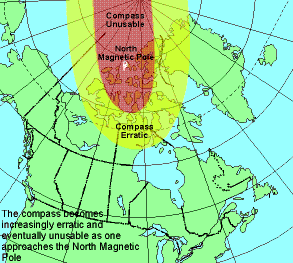
Area of Compass Unreliability
The horizontal force of the magnetic field, responsible for the direction in which a compass needle is oriented, decreases in strength as one approaches the North Magnetic Pole, where it is zero. Close to the pole, an area is reached where the frictional forces in the pivot are comparable to the horizontal forces of the magnetic field. The compass starts to behave erratically, and eventually, as the horizontal force decreases even more, the compass becomes unusable.Magnetic Reference Field Models
Since magnetic observations are neither uniformly nor densely distributed over the Earth, and since the magnetic field is constantly changing in time, it is not possible to obtain up-to-date values of declination directly from a database of past observations. Instead, the data are analyzed to produce a mathematical routine called a magnetic reference field "model", from which magnetic declination can be calculated. Global models are produced every five years. These constitute the series of International Geomagnetic Reference Field (IGRF) models. The latest IGRF was produced in 1995, and is valid until 2000. The Canadian Geomagnetic Reference Field (CGRF) is a model of the magnetic field over the Canadian region. It was produced using denser data over Canada than were used for the IGRF, and because the analysis was carried out over a smaller region, the CGRF can reproduce smaller spatial variations in the magnetic field than can the IGRF. The latest CGRF was also produced in 1995 and is valid until 2000. The accompanying declination chart is based on the CGRF. Since magnetic field models such as the IGRF and CGRF are approximations to observed data, a value of declination computed
using either of them is likely to differ somewhat from the "true" value at that location. It is generally agreed that the
IGRF achieves an overall accuracy of better than 1� in declination; the accuracy is better than this in densely surveyed
areas such as Europe and North America, and worse in oceanic areas such as the south Pacific. The accuracy of the CGRF, in
southern Canada, is about 0.5�. The accuracy of all models decreases in the Arctic near the North Magnetic Pole.
Magnetic field models are used to calculate magnetic declination by means of computer programs such as the Magnetic
Information Retrieval Program (MIRP), a software package developed by the Geomagnetism Program of the Geological Survey of
Canada. The user inputs the year, latitude and longitude and MIRP calculates the declination. MIRP is able to compute
values for any location on the Earth in the time period 1960 to 2000. For locations within Canada, MIRP computes values
using the CGRF. Outside Canada, values are calculated using the IGRF.
Since magnetic field models such as the IGRF and CGRF are approximations to observed data, a value of declination computed
using either of them is likely to differ somewhat from the "true" value at that location. It is generally agreed that the
IGRF achieves an overall accuracy of better than 1� in declination; the accuracy is better than this in densely surveyed
areas such as Europe and North America, and worse in oceanic areas such as the south Pacific. The accuracy of the CGRF, in
southern Canada, is about 0.5�. The accuracy of all models decreases in the Arctic near the North Magnetic Pole.
Magnetic field models are used to calculate magnetic declination by means of computer programs such as the Magnetic
Information Retrieval Program (MIRP), a software package developed by the Geomagnetism Program of the Geological Survey of
Canada. The user inputs the year, latitude and longitude and MIRP calculates the declination. MIRP is able to compute
values for any location on the Earth in the time period 1960 to 2000. For locations within Canada, MIRP computes values
using the CGRF. Outside Canada, values are calculated using the IGRF.
True North?
Many people are surprised to learn that a magnetic compass does not normally point to true north. In fact, over most of the Earth it points at some angle east or west of true (geographic) north. The direction in which the compass needle points is referred to as magnetic north, and the angle between magnetic north and the true north direction is called magnetic declination. You will often hear the terms "variation", "magnetic variation", or "compass variation" used in place of magnetic declination, especially by mariners.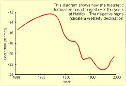 The magnetic declination
does not remain constant in time. Complex fluid motion in the outer core of the Earth
(the molten metallic region that lies from 2800 to 5000 km below the Earth's surface) causes the magnetic field to change
slowly with time. This change is known as secular variation. As an example, the accompanying diagram shows how the
magnetic declination has changed with time at Halifax. Because of secular variation, declination values shown on old
topographic, marine and aeronautical charts need to be updated if they are to be used without large errors. Unfortunately,
the annual change corrections given on most of these maps cannot be applied reliably if the maps are more than a few years
old since the secular variation also changes with time in an unpredictable manner.
The magnetic declination
does not remain constant in time. Complex fluid motion in the outer core of the Earth
(the molten metallic region that lies from 2800 to 5000 km below the Earth's surface) causes the magnetic field to change
slowly with time. This change is known as secular variation. As an example, the accompanying diagram shows how the
magnetic declination has changed with time at Halifax. Because of secular variation, declination values shown on old
topographic, marine and aeronautical charts need to be updated if they are to be used without large errors. Unfortunately,
the annual change corrections given on most of these maps cannot be applied reliably if the maps are more than a few years
old since the secular variation also changes with time in an unpredictable manner.
The position of the Magnetic North Pole
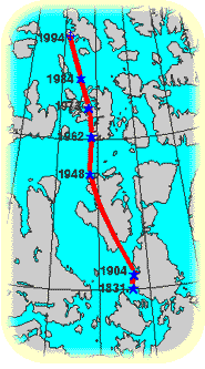
A pole position was [next] determined by Canadian government scientists shortly after World War II. Paul Serson and Jack Clark, of the Dominion Observatory, measured a dip of 89� 56' at Allen Lake on Prince of Wales Island. This, in conjunction with other observations made in the vicinity, showed that the pole had moved some 250 km northwest since the time of Amundsen's observations. Subsequent observations by Canadian government scientists in 1962, 1973, 1984, and most recently in 1994, showed that the general northwesterly motion of the pole is continuing, and that during this century it has moved on average 10 km per year .
Diurnal Motion of the Pole
It is important to realize that when we talk about the location of the pole, we are referring to an average position.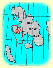 The pole wanders daily in a roughly elliptical path around this average position, and may frequently be as much as 80 km
away from this position when the Earth's magnetic field is disturbed. The diagram shows the average path on a magnetically
quiet day (inner ellipse) and on a magnetically disturbed day (outer ellipse).
The pole wanders daily in a roughly elliptical path around this average position, and may frequently be as much as 80 km
away from this position when the Earth's magnetic field is disturbed. The diagram shows the average path on a magnetically
quiet day (inner ellipse) and on a magnetically disturbed day (outer ellipse).
Why is the Pole Moving?
If, as Gilbert believed, the Earth acts as a large magnet, the pole would not move, at least not as rapidly as it does. We now know that the cause of the Earth's magnetic field is much more complex. We believe that it is produced by electrical currents that originate in the hot, liquid, outer core of the Earth. As a simple analogy, consider an electromagnet, in which we can produce a strong magnetic field by passing an electric current through a coil of wire. In nature, processes are seldom simple. The flow of electric currents in the core is continually changing, so the magnetic field produced by those currents also changes. This means that at the surface of the Earth, both the strength and direction of the magnetic field will vary over the years. This gradual change is called the secular variation of the magnetic field. The position of the North Magnetic Pole is strongly influenced by the secular variation in its vicinity. For example, if the dip is 90� at a given point this year, that point will be the North Magnetic Pole, by definition. However, because of secular variation, the dip at that point will change to 89�58' in about two years, so it will no longer be the pole. However, at some nearby point, the dip will have increased to 90�, and that point will have become the pole. In this manner, the pole slowly moves across the Arctic. The more rapid daily motion of the pole around its average position has an entirely different cause. If we measure the Earth's magnetic field continually, such as is done at a magnetic observatory, we will see that it changes during the course of a day, sometimes slowly, sometimes rapidly. The ultimate cause of these fluctuations is the Sun. The Sun constantly emits charged particles that, on encountering the Earth's magnetic field, cause electric currents to be produced in the upper atmosphere. These electric currents disturb the magnetic field, resulting in a temporary shift in the pole's position. The distance and speed of these displacements will, of course, depend on the nature of the disturbances in the magnetic field, but they are occurring constantly. When scientists try to determine the average position of the pole, they must average out all of these transient wanderings."How do racing pigeons "average out all these transient wanderings" in determining the location of the pole in their minds to be available as a reference useful for navigating their way home? The secular variation is not expected to present much of a problem to racing pigeons because it happens gradually over a long period of time but a different situation exists with the more rapid daily motion of the pole, especially when the earth's magnetic field is disturbed at which time the pole can move rapidly distances of up to 80 km. This may have dire consequences for our racing pigeons as their point of reference has moved enough to cause them to pass by their home loft.
Consider the eruption of Mount St Helen which disturbed the geomagnetic forces enough to move the pole suddenly causing the birds to "locate" their loft where it is not and thus creating difficulties for them. Many racing pigeon clubs all over North America experienced terrible returns from their organized races on that weekend.
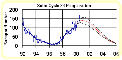 High sunspot numbers resulting in high geomagnetic disturbances and a high K factor will also result in rapid movement of
the magnetic pole. A "smash" toss need not necessarily occur when the K-factor (a 3 hourly local index of geomagnetic
activity) is high. It is the unreliability of the position of the magnetic pole
which will not inspire confidence regarding the bird's homing ability and consequently lead to poor orientation
in years of high solar activity, not necessarily on days of geomagnetic disturbances. Consider the
K factor on
High sunspot numbers resulting in high geomagnetic disturbances and a high K factor will also result in rapid movement of
the magnetic pole. A "smash" toss need not necessarily occur when the K-factor (a 3 hourly local index of geomagnetic
activity) is high. It is the unreliability of the position of the magnetic pole
which will not inspire confidence regarding the bird's homing ability and consequently lead to poor orientation
in years of high solar activity, not necessarily on days of geomagnetic disturbances. Consider the
K factor on
In spite of factors such as these similar to "moving the goal posts", there are thus always some birds much less affected than the majority. Racing pigeons have many tools at their disposal for finding their way home and it is the ones who can use most of them effectively who will succeed. Perhaps we should not lament the loss of inferior ones but welcome nature's method of helping us with the selection which must be done.